July 20th, 2011
By Tim Thornton

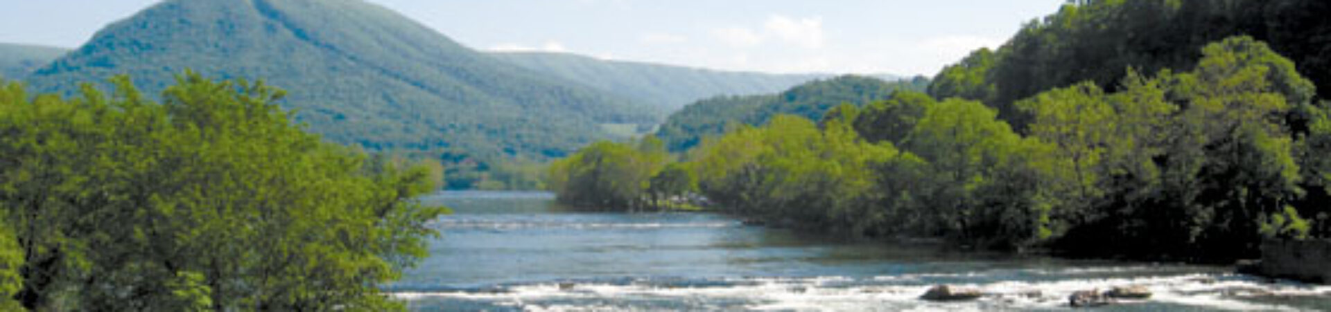
On the winding road between North Carolina mountain towns of West Jefferson and Boone, George Santucci is headed for the South Fork of the New River and the beginning of the 2011 New River Expedition.
It’s a three-state trip from a creekside park in Boone to the confluence of the New and Gauley rivers in Gauley Bridge, West Virginia. It’s a chance to reconnect with the river, Santucci said, a chance to get people who don’t know the river out on it so they can see what a wonder it is.
“The goal is to show the connectivity,” Santucci said at the beginning of a similar trip three years ago, “to show how every community along the river is connected and show how every community along this beautiful river impacts every community on downstream.
“We just want to get people connected to it, to get them to remember that this magnificent resource is out there, and have them join us.”
“It’s a rejuvenation for all of us,” he said on his way to this year’s trip, “like hard work can be.”
—–
Local Schedule:
8/6 Radford Bissett Park / Dudley’s Landing to 114
8/7 114 Bridge to Whitehorn
8/8 Whitehorn meet at Eggleston
8/9 Pembroke (meet at 460 Bridge) to Bluff City
8/10 Glen Lyn (meet at City Park) to Shankins Ferry
For more details see NCNR schedule pages
Video of the expedition is here: watch?v=qw037bKadfQ
—-
A raft of details
This year’s New River Expedition will use canoes and kayaks and rafts, following pretty much the same course the New River has followed since before the Appalachian Mountains existed.
The South Fork starts in the mountains above Boone, N.C. The North Fork starts to the west of there, on Snake Mountain. The streams wriggle and grow their way north, joining fewer than five river miles from the Virginia state line.
Taking the trip isn’t such hard work, but organizing it is. Santucci is executive director of the National Committee for the New River. He and his staff began planning this year’s expedition before last year’s ended.
Between July 20 and Aug. 17, the expedition will spend 20 days in the river, covering more than 200 river miles. There’s raft full of details to handle; government officials and citizens groups to coordinate with; river clean ups and cookouts to organize.
And less than a week into the trip, the National Committee has its annual meeting to introduce new board members and hand out awards and make sure the troops are fired up for the work of preserving the river and the land along its banks.
The National Committee for the New River was born in a dam fight.

In 1962, Appalachian Power, a subsidiary of American Electric Power, began planning to dam the New River. AEP already had three dams on the river: Buck and Byllesby, a pair of dams that make up a pumped storage facility in southern Virginia; and the hydroelectric dam that makes Claytor Lake, the centerpiece of Virginia’s Claytor Lake State Park.
Four other dams had been built on the river, most of them to generate electricity for factories. One built decades ago to control flooding downriver from Hinton, West Virginia is being retrofitted so it can generate power, too. The Hawk’s Nest dam, also in West Virgnia, redirects the river into a three-mile tunnel through a mountain. So little of the river remains between that tunnel’s mouth and the power plant’s outfall that stretch is called The Dries.
All of those dams are minor intrusions compared to the Blue Ridge Project. More than ninety river miles and more than 40,000 acres of Virginia and North Carolina would have been swallowed by reservoirs. The project didn’t die until September 1976, when Gerald Ford signed legislation that made 26 miles of the South Fork of the New a Wild and Scenic River.
The National Committee for the New River was what the folks who fought those dams left behind. The committee has helped expand North Carolina’s New River state Park. It helps landowners prevent erosion of their property. It works to get land along the riverbanks into conservation easements.
And, once a year, it gets as many people as it can to join a trip that begins where the river is first deep enough to float a canoe – barely – and ends where the New and the Gauley meet to form the Kanawha.
Origins of the expedition: the paddle on the wall
The New River Expedition is the descendent of a 2008 trip Shawn Hash, a Giles County, Virginia, outfitter, organized to commemorate the tenth anniversary of the New’s designation as an American Heritage River. Hash and some of his employees carried a commemorative paddle downriver, stopping at river festivals in Ashe County, NC, Radford, Virginia, and Hinton, West Virginia.
That paddle hangs on a wall in Tangent Oufitters’ Pembroke headquarters, but the National Committee for the New River saw an opportunity to bring river communities together and increase attention to the New River’s value and its perils.
The first year, 2009, the New River Expedition covered virtually every inch of the river between Boone and Gauley Bridge – about 345 river miles. The next year, the group surrendered to the difficulties of logistics and spent about 245 miles in the water. This year, the number will be closer to 200 miles. Some folks will paddle most of the expedition’s route. Others will join for just a day or two.
And old river’s history
Native Americans beat Europeans to the river by a few thousand years, but when Abraham Wood “discovered” the river in the 17th century, he named it after himself. The name didn’t stick, however, and when When Thomas Batts and Robert Fallam followed the New River in 1671, they thought it was a route to the Pacific Ocean. They were sure they saw the tide coming in near Pearisburg, Virginia.
“We set up a stick by the water side,” their journal says, “but found it ebbed very slowly.”

The New River in “the dries” in West Virginia. Photo by Tim Thornton.
In 1812, John Marshall, the 57-year-old the Chief Justice of the Unites States Supreme Court, led a 250-mile trip from Lynchburg to the Kanawha River, commissioned by the Virginia General Assembly to find a potential river and canal route from Richmond to the Ohio River. The group used batteaux, the cargo-hauling boats that plied the New until the 1930s. They were up to seventy-five feet long and carried as much as sixteen tons of goods in as little as one foot of water.
The New River Atlas tells of three brothers about to go off to college in 1901. Craving one last adventure together, they built a row boat and set off from their home near Crumpler, North Carolina, headed for Hinton, West Virginia, 200 miles away. They saw the river’s first hydroelectric dam under construction.
When it looked like Appalacahian Power was going to build its dams in Grayson County, Proctor Kirk and three of his buddies came to North Carolina from their homes around Hinton, West Virginia, to run the river while they still could.
“You couldn’t convince us the dam wasn’t going to be built, even though we were fighting like hell. Pardon my expression,” Kirk said. “And we decided that we better get down there if we were going to see what the river looked like and run the river.”
The men’s wives drove them down to where the New River gets narrow and dropped them off. Then Kirk and his three buddies headed home to Hinton in a pair of aluminum canoes.
The struggle for scenic river designation in Virginia
North Carolina has its 26 miles of state and federally designated scenic river; 53 miles of West Virginia’s section is a national river, part of the National Park system. None of Virginia’s section of the New has any similar designation, though some people have tried to change that.
In 2007, when a U.S. senator from North Carolina tried to add 21 miles of the New that twists back and forth across the North Carolina-Virginia line to the Wild & Scenic list, Virginia legislators opposed it and the legislation died.
Another Virginia section of the New has been under consideration for national Wild and Scenic status since 1992. In 2009, the National Park Service released a study that said the six-mile section, plus about 13 miles of river in West Virginia, qualifies, but shouldn’t be included. There’s not enough local support, according to the report. So the Giles County Board of Supervisors, the county’s representatives in the General Assembly, then-Congressman Rick Boucher’s staff and local citizens’ groups all said they are for it.
Nothing happened.
What you’ll see on the river
That stretch of river, which runs from the Giles County town of Glen Lyn to West Virginia’s Bluestone Lake has lots of bass, as much of the New River does. But it also has walleye and excellent habitat for hellbenders, the largest salamander in North America. The nocturnal predators can get close to three feet long and live more than 30 years.
Eagles and osprey are common and the section holds what The New River Atlas calls “the best batteaux sluices on the New River.” The Army Corps of Engineers controls the land in Virginia. The West Virginia Department of Natural Resources manages the land past State Line Falls. For miles, the only hint of development visible from the river is an occasional corn field.
Noah Adams, whose bestselling book Far Appalachia followed the New River from Snake Mountain to Gauley Bridge, called it one of the most pristine sections of the river. “You see West Virginia up there on the horizon,” he said, “and there’s nothing around you and that’s just exactly what your ancestors would have seen.”
Santucci called it “one of the most spectacular sections of the river that’s not already a national park or state park.”
Recognizing those treasures and preserving them are important, Santucci said. And he’s convinced more people are coming to realize that there’s economic value in the river, not just from the power it can generate and the water it can provide, but from the businesses it can generate.
Virginia’s push to market its natural and cultural heritage is an example of the way people are making money and building community by promoting and preserving what they have. The same thing is happening in West Virginia around the New River Gorge, he said, pointing out that the Boy Scouts are creating their largest camp near there.
When Bill Clinton traveled to Ashe County, North Carolina, to sign legislation making the New an American Heritage River, the president talked about the economic advantages the designation would bring, but he ended his speech with this:
“This ancient river has flowed through the heart of this land for millions of years – hundreds of millions of years longer than blood has flowed through any human heart. The Cherokee even say that this was the very first river created by the Great Spirits’ hand. Who are we, such brief visitors, on this Earth to disturb it? But when we cherish it and save it and hand it on to our children, we have done what we were charged to do, not only in our own Constitution and history, but by our Maker.”
—–
To learn more about the schedule of this year’s New River Expedition, to contact outfitters handling boats and shuttles and to find out how and where you can join up with the trip or join in a river cleanup, go to http://ncnr.org.